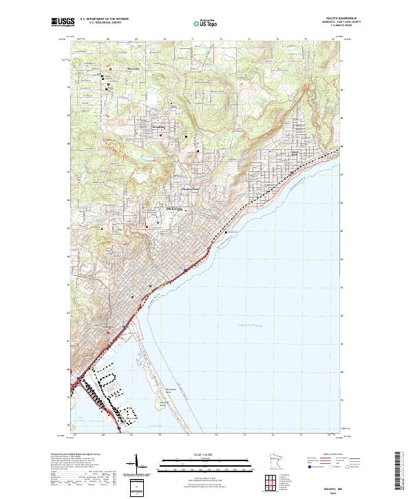
2022 Map of Duluth
USGS Topo · Published 2022About this map
Duluth and its surrounding neighborhoods like Woodland, Hunters Park, and Lester Park define this portrait of the North Shore. The city's geography is shaped by the dramatic rise from Lake Superior toward the ridge, where the Superior Hiking Trl and E Skyline Pkwy offer overlooks of the harbor and the industrial waterfront at Rices Point. The map preserves a dense concentration of cultural history, particularly in the numerous faith-based burial grounds north of the city center, including Adas Israel Cem, Tifereth Israel Cem, and Temple Emanuel Cem. The landscape is etched by several watercourses including Tischer Cr and Chester Cr, which cut through the urban grid toward the lake. Educational and civic anchors like the University of Minnesota Duluth and the Saint Louis County Courthouse mark the city's modern infrastructure alongside the narrow profile of Minnesota Point.
Find a feature on this map
62 named features on this map. Tap any name to fly to it.
Don’t see what you’re looking for? This feature index may not catch every label — zoom into the map to look around manually.
Map Details
Editions of this 2022 Duluth Map
This is the sole edition of this map. No revisions or reprints were ever made.
Historical Maps of Rice Lake Annex Through Time
7 maps found