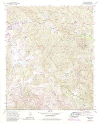
1972 Map of Dulzura
USGS Topo · Published 1984About this map
McGinty Mountain and the San Ysidro Mountains dominate this landscape southeast of San Diego, where rural life in the early 1970s was defined by scattered ranches and rugged truck trails. The map highlights the transition of the Cleveland National Forest as it meets private holdings like Mountain Shadows Ranch and Honey Springs Ranch. Human activity is centered along the winding Dulzura Road, linking settlements like North Jamul and Dulzura. Local history is visible in features such as the St Francis Xavier Cem, the Jamul-Las Flores Sch, and the legendary Peg Leg Mine near the northern boundary. The terrain is deeply incised by drainages such as Hollenbeck Canyon and Lee Valley, reflecting an era before significant suburban expansion reached these inland canyons.
Find a feature on this map
49 named features on this map. Tap any name to fly to it.
Don’t see what you’re looking for? This feature index may not catch every label — zoom into the map to look around manually.
Map Details
Editions of this 1972 Dulzura Map
4 editions found
Other maps of this area

1893 · El Cajon
USGS Topo · 1:62,500

1901 · Elcajon
USGS Topo · 1:62,500

1903 · Cuyamaca
USGS Topo · 1:125,000

1903 · Elcajon
USGS Topo · 1:62,500

1904 · Southern California Sheet No. 2
USGS Topo · 1:250,000

1939 · El Cajon
USGS Topo · 1:62,500

1942 · Potrero
USGS Topo · 1:48,000

1942 · El Cajon
USGS Topo · 1:62,500

1942 · Cuyamaca Peak
USGS Topo · 1:62,500

1943 · Jamul
USGS Topo · 1:62,500