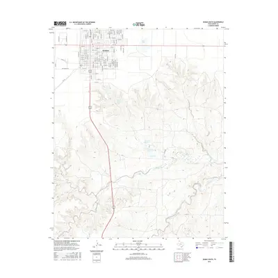
2016 Map of Dumas South
USGS Topo · Published 2016About this map
Dumas serves as the primary hub on this Moore County landscape, its grid extending southward into a region defined by localized catchments and seasonal drainage. Residential streets like Shamrock Dr and Geary Rd transition into a rural expanse where water management is critical to ranching and local utility. This is evident in the cluster of small reservoirs south of the town center, including the City of Dumas Lake and the John Coon Ranch Lake. The terrain is etched by the meandering courses of Big Blue Creek and Running Water Creek, which cut through the high plains. For those tracing family history, the Dumas Cem is a prominent landmark situated on the western edge of the settlement, providing a genealogical anchor for this Texas Panhandle community.
Find a feature on this map
94 named features on this map. Tap any name to fly to it.
Don’t see what you’re looking for? This feature index may not catch every label — zoom into the map to look around manually.
Map Details
Editions of this 2016 Dumas South Map
This is the sole edition of this map. No revisions or reprints were ever made.
Other maps of this area

1936 · Fourways
USGS Topo · 1:62,500

1953 · Masterson
USGS Topo · 1:24,000

1953 · Spencer Draw
USGS Topo · 1:24,000

1954 · Tucumcari
USGS Topo · 1:250,000

1954 · Amarillo
USGS Topo · 1:250,000

1958 · Amarillo
USGS Topo · 1:250,000

1958 · Tucumcari
USGS Topo · 1:250,000

1963 · Stallwitz Lake
USGS Topo · 1:24,000

1965 · Dumas South
USGS Topo · 1:24,000
1965 · Stallwitz Lake NE
USGS Topo · 1:24,000