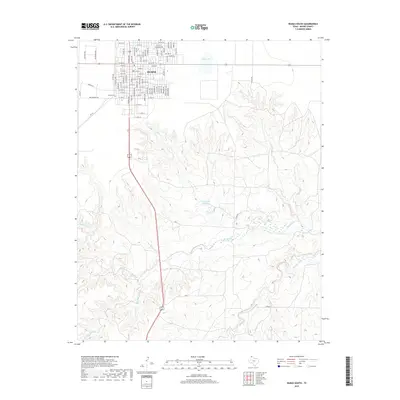
2019 Map of Dumas South
USGS Topo · Published 2019About this map
Dumas serves as the focal point of this Moore County landscape, showing the town's residential and commercial grid as it stood in the late 2010s. The survey captures a high-plains geography where urban development meets a complex system of seasonal drainage and intermittent lakes. Key water features such as Bone Lake to the north and Coon Lake Number 2 to the south illustrate the natural depressions characteristic of the Panhandle. To the west, the Dumas Cem is a significant site for genealogical research, situated near the intersection of the city's expanding street network and rural access roads. The southern half of the map is dominated by the winding paths of Big Blue Creek and Running Water Creek, showing the natural erosion patterns and drainage basins that define the local topography outside of the main settlement.
Find a feature on this map
97 named features on this map. Tap any name to fly to it.
Don’t see what you’re looking for? This feature index may not catch every label — zoom into the map to look around manually.
Map Details
Editions of this 2019 Dumas South Map
This is the sole edition of this map. No revisions or reprints were ever made.
Other maps of this area

1936 · Fourways
USGS Topo · 1:62,500

1953 · Masterson
USGS Topo · 1:24,000

1953 · Spencer Draw
USGS Topo · 1:24,000

1954 · Tucumcari
USGS Topo · 1:250,000

1954 · Amarillo
USGS Topo · 1:250,000

1958 · Amarillo
USGS Topo · 1:250,000

1958 · Tucumcari
USGS Topo · 1:250,000

1963 · Stallwitz Lake
USGS Topo · 1:24,000

1965 · Dumas South
USGS Topo · 1:24,000
1965 · Stallwitz Lake NE
USGS Topo · 1:24,000