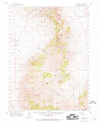
1961 Map of Dun Glen
USGS Topo · Published 1969About this map
Auld Lang Syne Peak and the high ridges of the Pershing County interior define this mid-century landscape, where rugged mining claims and remote ranching outposts mark the terrain. The map documents the Dun Glen (Site) near the canyon mouth, once a bustling settlement now reduced to a historical marker. Further south, the high desert is dotted with active and former workings such as the Yellowstone Mine and Wadley Mine, linked by a network of jeep trails and tracks that follow the natural contours of Inskip Canyon and Leach Canyon.
Find a feature on this map
65 named features on this map. Tap any name to fly to it.
Don’t see what you’re looking for? This feature index may not catch every label — zoom into the map to look around manually.
Map Details
Editions of this 1961 Dun Glen Map
3 editions found

Other maps of this area

1931 · Lovelock
USGS Topo · 1:250,000

1932 · Sonoma Range
USGS Topo · 1:250,000

1935 · Lovelock
USGS Topo · 1:250,000

1939 · Sonoma Range
USGS Topo · 1:250,000

1939 · Eugene Mountains Area
USGS Topo · 1:62,500

1942 · Eugene Mountains Area
USGS Topo · 1:62,500

1954 · Unionville
USGS Topo · 1:62,500

1955 · Lovelock
USGS Topo · 1:250,000

1955 · Winnemucca
USGS Topo · 1:250,000

1956 · Imlay
USGS Topo · 1:62,500