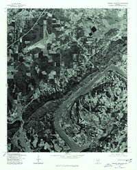
1975 Map of Dunaway Mountain
USGS Topo · Published 1977About this map
H Neely Henry Lake dominates the central landscape of this 1975 orthophotoquad, winding through the terrain south of the industrial and residential corridors of Gadsden. This photographic survey provides a direct visual record of the region's development during the mid-1970s, showing the precise density of suburban expansion in Rainbow City and the surrounding Etowah County countryside. Unlike a traditional topographic map, this imagery reveals the exact patterns of land use, from the clear-cut agricultural fields along the riverbanks to the wooded ridges and early highway infrastructure. The map serves as a primary source for understanding the mid-century footprint of these communities before later decades of further commercial and residential growth altered the river-valley landscape.
Find a feature on this map
3 named features on this map. Tap any name to fly to it.
Don’t see what you’re looking for? This feature index may not catch every label — zoom into the map to look around manually.
Map Details
Editions of this 1975 Dunaway Mountain Map
This is the sole edition of this map. No revisions or reprints were ever made.
Other maps of this area

1885 · Gadsden
USGS Topo · 1:125,000

1888 · Gadsden
USGS Topo · 1:125,000

1889 · Springville
USGS Topo · 1:125,000

1892 · Springville
USGS Topo · 1:125,000

1892 · Gadsden
USGS Topo · 1:125,000

1893 · Fort Payne
USGS Topo · 1:125,000

1895 · Gadsden
USGS Topo · 1:125,000

1898 · Fort Payne
USGS Topo · 1:125,000

1900 · Fort Payne
USGS Topo · 1:125,000

1900 · Anniston
USGS Topo · 1:125,000