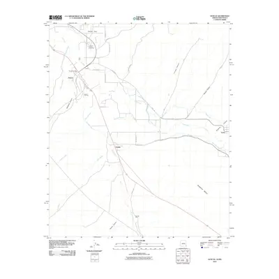
2010 Map of Duncan
USGS Topo · Published 2010About this map
The Gila River corridor near the Arizona-New Mexico border defines this agricultural landscape, where a complex network of irrigation channels supports the valley. Significant water projects like the New Model Canal, Sunset Canal, and Valley Canal weave through the terrain, illustrating the historical reliance on controlled water for desert farming. Centered around the town of Duncan, the map highlights local hubs such as the Greenlee County Fairgrounds and the Duncan Post Office. Small settlements and family landmarks, including Purdy, Franklin, and the Rainville Ranch, are scattered along the river's path, while the high ground of Pearson Mesa rises to the south. The layout of roads like Old Virden Rd and Virden Hwy connects these disparate farming communities and small towns like Virden across the state line.
Find a feature on this map
35 named features on this map. Tap any name to fly to it.
Don’t see what you’re looking for? This feature index may not catch every label — zoom into the map to look around manually.
Map Details
Editions of this 2010 Duncan Map
This is the sole edition of this map. No revisions or reprints were ever made.
Other maps of this area

1954 · Silver City
USGS Topo · 1:250,000

1958 · Silver City
USGS Topo · 1:250,000

1959 · Steeple Rock
USGS Topo · 1:62,500

1959 · Canador Peak
USGS Topo · 1:62,500

1959 · York Valley
USGS Topo · 1:62,500

1960 · Duncan
USGS Topo · 1:62,500

1962 · Silver City
USGS Topo · 1:250,000
1986 · Sheldon
USGS Topo · 1:24,000
1986 · Duncan
USGS Topo · 1:24,000
1986 · Hot Well
USGS Topo · 1:24,000