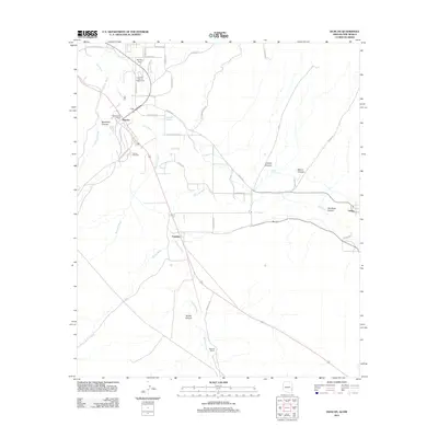
2011 Map of Duncan
USGS Topo · Published 2011About this map
The Gila River corridor serves as the primary axis of settlement in this borderlands region, anchoring the communities of Duncan and Franklin in Arizona and Virden just across the line in New Mexico. This 2011 survey captures the agricultural and residential layout of the valley, where irrigation and proximity to the river have historically dictated the placement of homesteads and roads. Local institutions such as the Greenlee County Fairgrounds, the Duncan Post Office, and the Duncan Cemetery provide essential points of reference for genealogical and community research. Beyond the fertile valley, the terrain is defined by a series of drainages and landmarks named for early settlers, including Rainville Ranch and Hunter Flat. The landscape is etched with numerous canyons such as Blackfield Canyon and Carlisle Canyon, illustrating the transition from the river basin to the more arid surrounding uplands.
Find a feature on this map
44 named features on this map. Tap any name to fly to it.
Don’t see what you’re looking for? This feature index may not catch every label — zoom into the map to look around manually.
Map Details
Editions of this 2011 Duncan Map
This is the sole edition of this map. No revisions or reprints were ever made.
Other maps of this area

1954 · Silver City
USGS Topo · 1:250,000

1958 · Silver City
USGS Topo · 1:250,000

1959 · Steeple Rock
USGS Topo · 1:62,500

1959 · Canador Peak
USGS Topo · 1:62,500

1959 · York Valley
USGS Topo · 1:62,500

1960 · Duncan
USGS Topo · 1:62,500

1962 · Silver City
USGS Topo · 1:250,000
1986 · Sheldon
USGS Topo · 1:24,000
1986 · Duncan
USGS Topo · 1:24,000
1986 · Hot Well
USGS Topo · 1:24,000