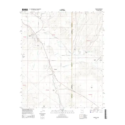
2014 Map of Duncan
USGS Topo · Published 2014About this map
The Gila River corridor serves as the lifeblood of this border region, supporting a network of agricultural infrastructure such as the Sunset Canal, Valley Canal, and New Model Canal. These waterways snake through the valley to sustain the settlements of Duncan and Franklin on the Arizona side, as well as Virden across the border in New Mexico. The landscape is defined by the contrast between these irrigated lowlands and the higher, arid terrain of Pearson Mesa and Hunter Flat. Local history is anchored at the Duncan Valley Cem, while the rugged geography is marked by numerous drainages like Blackfield Canyon and Stocks Canyon. The proximity of the state line between Arizona and New Mexico, cutting through the high desert and agricultural fields, illustrates the shared cross-border economy and transport links of the era, primarily connected by the path of Us-70.
Find a feature on this map
45 named features on this map. Tap any name to fly to it.
Don’t see what you’re looking for? This feature index may not catch every label — zoom into the map to look around manually.
Map Details
Editions of this 2014 Duncan Map
This is the sole edition of this map. No revisions or reprints were ever made.
Other maps of this area

1954 · Silver City
USGS Topo · 1:250,000

1958 · Silver City
USGS Topo · 1:250,000

1959 · Steeple Rock
USGS Topo · 1:62,500

1959 · Canador Peak
USGS Topo · 1:62,500

1959 · York Valley
USGS Topo · 1:62,500

1960 · Duncan
USGS Topo · 1:62,500

1962 · Silver City
USGS Topo · 1:250,000
1986 · Sheldon
USGS Topo · 1:24,000
1986 · Duncan
USGS Topo · 1:24,000
1986 · Hot Well
USGS Topo · 1:24,000