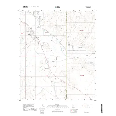
2018 Map of Duncan
USGS Topo · Published 2018About this map
The Gila River winds through this arid borderland, where the irrigation network of the Sunset Canal, New Model Canal, and Valley Canal supports the agricultural pockets around Duncan and Franklin. This area, straddling the state line near Virden, is defined by a landscape of rugged canyons and broad mesas. To the north, Hunter Flat and Blackfield Canyon dominate the topography, while Pearson Mesa occupies the southern reaches near the New Mexico boundary.
Find a feature on this map
68 named features on this map. Tap any name to fly to it.
Don’t see what you’re looking for? This feature index may not catch every label — zoom into the map to look around manually.
Map Details
Editions of this 2018 Duncan Map
This is the sole edition of this map. No revisions or reprints were ever made.
Other maps of this area

1954 · Silver City
USGS Topo · 1:250,000

1958 · Silver City
USGS Topo · 1:250,000

1959 · Steeple Rock
USGS Topo · 1:62,500

1959 · Canador Peak
USGS Topo · 1:62,500

1959 · York Valley
USGS Topo · 1:62,500

1960 · Duncan
USGS Topo · 1:62,500

1962 · Silver City
USGS Topo · 1:250,000
1986 · Sheldon
USGS Topo · 1:24,000
1986 · Duncan
USGS Topo · 1:24,000
1986 · Hot Well
USGS Topo · 1:24,000