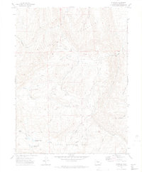
1971 Map of Dunckley
USGS Topo · Published 1974About this map
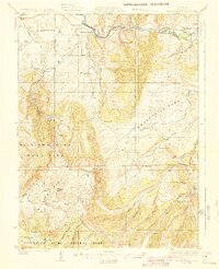
The Williams Fork Mountains dominate this high-altitude landscape in Routt National Forest, characterized by complex water management and early energy exploration. By the early 1970s, the terrain was marked by numerous Drill Holes and a Gas Well along Sage Creek, signaling the era's focus on resource extraction. This activity contrasts with the agricultural infrastructure of the lowland Williams Park, where a network of irrigation channels like the Side Highland Ditch and East Side Ditch diverted water from Fish Creek. Remote water storage is a recurring theme, seen in the Sellers-Crowell Reservoir and the Dunckley and Dubeau Reservoir near Dubeau Meadow. The map also preserves the site of the small settlement at Dunckley, located at the junction of mountain trails and park-bound streams.
Find a feature on this map
39 named features on this map. Tap any name to fly to it.
Don’t see what you’re looking for? This feature index may not catch every label — zoom into the map to look around manually.
Map Details
Editions of this 1971 Dunckley Map
3 editions found

Other maps of this area

1916 · Daton Peak
USGS Topo · 1:62,500
1920 · Daton Peak
USGS Topo · 1:62,500
1924 · Mt. Harris
USGS Topo · 1:48,000
1926 · Mount Harris
USGS Topo · 1:62,500

1954 · Craig
USGS Topo · 1:250,000

1957 · Craig
USGS Topo · 1:250,000

1958 · Craig
USGS Topo · 1:250,000

1960 · Craig
USGS Topo · 1:250,000

1962 · Craig
USGS Topo · 1:250,000

1964 · Craig
USGS Topo · 1:250,000