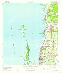
1943 Map of Dunedin
USGS Topo · Published 1961About this map
St Joseph Sound and Clearwater Harbor dominate this coastal landscape, separating the developing Pinellas mainland from the barrier islands of Caladesi Island and Clearwater Beach Island. Inland, the Atlantic Coast Line railroad dictates the pattern of settlement, linking established communities like Palm Harbor, Ozona, and Dunedin. The geography is defined by a dense network of water features, including Sutherland Bayou, Smith Bayou, and Curlew Creek, which feed into the sound. Notable localized landmarks such as the Wall Springs area and the small clusters at Crystal Beach and Seaside Point illustrate the early mid-century residential footprint of the Gulf coast. Extensive salt marshes and bayous like Cloesterman Bayou and Boggy Bayou characterize the northern reaches, while the Dunedin City Bdy indicates the early urban limits of this growing waterfront community.
Find a feature on this map
52 named features on this map. Tap any name to fly to it.
Don’t see what you’re looking for? This feature index may not catch every label — zoom into the map to look around manually.
Map Details
Editions of this 1943 Dunedin Map
3 editions found
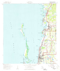
Other maps of this area

1921 · Sand Key
USGS Topo · 1:62,500

1921 · St Petersburg
USGS Topo · 1:62,500

1943 · Safety Harbor
USGS Topo · 1:31,680

1943 · Dunedin
USGS Topo · 1:31,680

1943 · Tarpon Springs
USGS Topo · 1:31,680

1943 · Clearwater
USGS Topo · 1:24,000

1943 · Elfers
USGS Topo · 1:24,000

1943 · Oldsmar
USGS Topo · 1:24,000

1944 · Elfers
USGS Topo · 1:31,680

1944 · Oldsmar
USGS Topo · 1:31,680