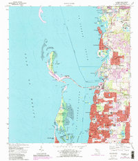
1974 Map of Dunedin
USGS Topo · Published 1988About this map
St Joseph Sound and its protective barrier islands define this coastal landscape during a period of significant suburban expansion. The 1980s updates, shown in purple, reveal the intensifying development of Dunedin and Palm Harbor, where new residential streets and infrastructure began to fill the gaps between older coastal settlements like Ozona and Crystal Beach. On the mainland, local institutions such as Trinity College, Our Lady of Lourdes Sch, and the Dunedin Cem serve as vital anchors for genealogists and local historians tracing the community's growth.
Find a feature on this map
72 named features on this map. Tap any name to fly to it.
Don’t see what you’re looking for? This feature index may not catch every label — zoom into the map to look around manually.
Map Details
Editions of this 1974 Dunedin Map
3 editions found
Other maps of this area

1921 · Sand Key
USGS Topo · 1:62,500

1921 · St Petersburg
USGS Topo · 1:62,500

1943 · Safety Harbor
USGS Topo · 1:31,680

1943 · Dunedin
USGS Topo · 1:31,680

1943 · Tarpon Springs
USGS Topo · 1:31,680

1943 · Clearwater
USGS Topo · 1:24,000

1943 · Elfers
USGS Topo · 1:24,000

1943 · Oldsmar
USGS Topo · 1:24,000

1944 · Elfers
USGS Topo · 1:31,680

1944 · Oldsmar
USGS Topo · 1:31,680