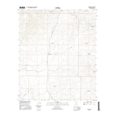
2017 Map of Dunken
USGS Topo · Published 2017About this map
The settlement of Dunken serves as a small anchor in this high-desert landscape of Chaves County. Situated along Co Rd 24, the community is surrounded by a network of drainage systems and ranch access roads. The Rio Peñasco cuts through the northern section of the map, while Bluewater Creek and its tributary Bluewater Cr flow through the central basins. The area is defined by its deep canyons and ranching infrastructure, with labels such as Jennings Ranch and Cauhape Ranch Rd indicating the ongoing agricultural utility of the land. Deep geographical cuts like Big Cherry Canyon and Little Cuevo Canyon dominate the eastern topography. The map illustrates a contemporary view of New Mexico's rangeland, where named wells like those along Dunken Well Rd and local routes like Champion Canyon Rd mark the limited but vital human presence in the drainage of the Peñasco valley.
Find a feature on this map
28 named features on this map. Tap any name to fly to it.
Don’t see what you’re looking for? This feature index may not catch every label — zoom into the map to look around manually.
Map Details
Editions of this 2017 Dunken Map
This is the sole edition of this map. No revisions or reprints were ever made.
Other maps of this area

1954 · Carlsbad
USGS Topo · 1:250,000

1958 · Carlsbad
USGS Topo · 1:250,000

1962 · Dunken
USGS Topo · 1:62,500

1963 · Robertson Canyon
USGS Topo · 1:24,000
1963 · Elk
USGS Topo · 1:24,000

1965 · Lewis Peak NE
USGS Topo · 1:24,000

1965 · Chimney Lake
USGS Topo · 1:24,000

1965 · Lewis Peak
USGS Topo · 1:24,000

1979 · Alamogordo
USGS Topo · 1:100,000
1989 · Dunken
USGS Topo · 1:24,000