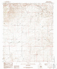
1989 Map of Dunken
USGS Topo · Published 1989About this map
Dunken anchors this 1989 topographic study of southeastern New Mexico, where the high-desert landscape is defined by its sparse water sources and topographic relief. The map reveals a reliance on isolated infrastructure to support life and livestock, notably the Dunken Windmill and Treat Windmill, alongside scattered water points like Alamo Well and Viejo Well. An Abandoned Ditch near the center of the sheet suggests earlier attempts at managing the erratic flow of the local drainage system.
Find a feature on this map
15 named features on this map. Tap any name to fly to it.
Don’t see what you’re looking for? This feature index may not catch every label — zoom into the map to look around manually.
Map Details
Editions of this 1989 Dunken Map
This is the sole edition of this map. No revisions or reprints were ever made.
Other maps of this area

1954 · Carlsbad
USGS Topo · 1:250,000

1958 · Carlsbad
USGS Topo · 1:250,000

1962 · Dunken
USGS Topo · 1:62,500

1963 · Robertson Canyon
USGS Topo · 1:24,000
1963 · Elk
USGS Topo · 1:24,000

1965 · Lewis Peak NE
USGS Topo · 1:24,000

1965 · Chimney Lake
USGS Topo · 1:24,000

1965 · Lewis Peak
USGS Topo · 1:24,000

1979 · Alamogordo
USGS Topo · 1:100,000
1989 · Thimble Canyon
USGS Topo · 1:24,000