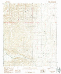
1989 Map of Thimble Canyon
USGS Topo · Published 1989About this map
Rio Peñasco winds through the southern reaches of this landscape in Chaves County, New Mexico, marking the primary drainage in an area defined by deep canyons and high ridges. The terrain is etched with seasonal watercourses and names that suggest the practical necessities of ranching and survival in this arid environment. Key water sources like Watts Tank, Eagle Well, and Lake Windmill are vital landmarks scattered across the township, supporting the local economy alongside the Gravel Pits found in the south. A network of 4wd roads and trails provides access through the rugged geography, connecting the upper reaches of Thimble Canyon and Cherry Canyon to the broader valleys below. This map illustrates the intersection of natural drainage patterns, such as Thimble Creek and Eagle Creek, with the established range infrastructure of the late twentieth century.
Find a feature on this map
17 named features on this map. Tap any name to fly to it.
Don’t see what you’re looking for? This feature index may not catch every label — zoom into the map to look around manually.
Map Details
Editions of this 1989 Thimble Canyon Map
This is the sole edition of this map. No revisions or reprints were ever made.
Other maps of this area

1954 · Carlsbad
USGS Topo · 1:250,000

1955 · Roswell
USGS Topo · 1:250,000

1958 · Carlsbad
USGS Topo · 1:250,000

1958 · Roswell
USGS Topo · 1:250,000

1961 · Flying H
USGS Topo · 1:62,500

1962 · Roswell
USGS Topo · 1:250,000

1962 · Dunken
USGS Topo · 1:62,500

1963 · Clements Ranch
USGS Topo · 1:24,000

1963 · Robertson Canyon
USGS Topo · 1:24,000
1963 · Elk
USGS Topo · 1:24,000