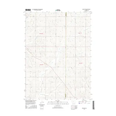
2015 Map of Dunlap NW
USGS Topo · Published 2015About this map
The borderlands of Monona Co and Crawford Co are defined by the intricate dendritic drainage systems of the Missouri River watershed. This topographical study focuses on the rolling terrain where numerous tributaries of Willow Creek converge, including S Willow Cr and Middle Willow Cr. The agricultural grid of the Loess Hills is evident through the dense network of local routes like Co Hwy E54, Sumac Ave, and O'Banion Rd that trace the ridges and valleys between small watercourses. One of the few larger bodies of water, Mill Creek Lake, sits near the northern boundary, serving as a landmark in a landscape dominated by township sections like t83n r42w and t82n r41w. The map preserves the exact alignment of rural infrastructure, from the path of Norway Cr to the various farm-to-market roads that have sustained this Iowa farming region for generations.
Find a feature on this map
43 named features on this map. Tap any name to fly to it.
Don’t see what you’re looking for? This feature index may not catch every label — zoom into the map to look around manually.
Map Details
Editions of this 2015 Dunlap NW Map
This is the sole edition of this map. No revisions or reprints were ever made.
Other maps of this area

1954 · Omaha
USGS Topo · 1:250,000

1954 · Fort Dodge
USGS Topo · 1:250,000

1957 · Omaha
USGS Topo · 1:250,000

1957 · Fort Dodge
USGS Topo · 1:250,000

1958 · Omaha
USGS Topo · 1:250,000

1958 · Fort Dodge
USGS Topo · 1:250,000
1971 · Mapleton SE
USGS Topo · 1:24,000

1971 · Moorhead SE
USGS Topo · 1:24,000

1971 · Ute
USGS Topo · 1:24,000

1971 · Dunlap SW
USGS Topo · 1:24,000