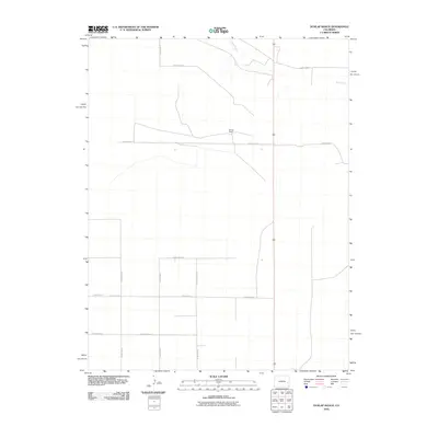
2010 Map of Dunlap Ranch
USGS Topo · Published 2010About this map
Dunlap Ranch serves as a primary landmark in this section of Cheyenne County, Colorado, highlighting the persistent cattle-ranching heritage of the High Plains. The landscape is defined by a rigid grid of rural infrastructure, where long stretches of road such as County Road A and County Road Z intersect at regular intervals to organize the vast open range. Apart from these human-made boundaries, the natural drainage of Rush Creek meanders through the northern portion of the map, providing a crucial water source in an otherwise arid environment. This survey illustrates the spatial organization of early 21st-century agricultural life, showing how property access via roads like County Road W and County Road V supports the isolated operations of the eastern Colorado plains.
Find a feature on this map
11 named features on this map. Tap any name to fly to it.
Don’t see what you’re looking for? This feature index may not catch every label — zoom into the map to look around manually.
Map Details
Editions of this 2010 Dunlap Ranch Map
This is the sole edition of this map. No revisions or reprints were ever made.
Other maps of this area

1891 · Kit Carson
USGS Topo · 1:125,000

1892 · Lamar
USGS Topo · 1:125,000

1893 · Kit Carson
USGS Topo · 1:125,000

1954 · Lamar
USGS Topo · 1:250,000

1958 · Lamar
USGS Topo · 1:250,000
1968 · Alkali Lake
USGS Topo · 1:24,000

1968 · Hawkins
USGS Topo · 1:24,000
1968 · Eads
USGS Topo · 1:24,000

1981 · Cheyenne Wells
USGS Topo · 1:100,000

1982 · Kit Carson 4 NW
USGS Topo · 1:24,000