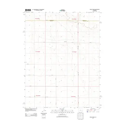
2013 Map of Dunlap Ranch
USGS Topo · Published 2013About this map
The high plains of eastern Colorado are defined by a vast, organized grid of county roads and intermittent waterways in this 2013 survey. The terrain is notably sparse, centered on the Dunlap Ranch and Oswald Ranch, which anchor the local landscape between the Cheyenne Co Kiowa Co boundary. Transport is dominated by the north-south corridor of Us-287 N, which cuts a straight path through the undulating contours of the region. The drainage of Rush Creek provides the primary topographic variation in the northern sections of the map, crossing underneath the highway as it winds through the prairie. This map records the modern cattle ranching and agricultural framework of the area, evidenced by the precise section lines and extensive network of local thoroughfares including CO Road A, CO Road Z, and CO Road W.
Find a feature on this map
21 named features on this map. Tap any name to fly to it.
Don’t see what you’re looking for? This feature index may not catch every label — zoom into the map to look around manually.
Map Details
Editions of this 2013 Dunlap Ranch Map
This is the sole edition of this map. No revisions or reprints were ever made.
Other maps of this area

1891 · Kit Carson
USGS Topo · 1:125,000

1892 · Lamar
USGS Topo · 1:125,000

1893 · Kit Carson
USGS Topo · 1:125,000

1954 · Lamar
USGS Topo · 1:250,000

1958 · Lamar
USGS Topo · 1:250,000
1968 · Alkali Lake
USGS Topo · 1:24,000

1968 · Hawkins
USGS Topo · 1:24,000
1968 · Eads
USGS Topo · 1:24,000

1981 · Cheyenne Wells
USGS Topo · 1:100,000

1982 · Kit Carson 4 NW
USGS Topo · 1:24,000