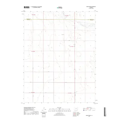
2019 Map of Dunlap Ranch
USGS Topo · Published 2019About this map
Dunlap Ranch sits as a primary landmark in this rural expanse on the high plains of Eastern Colorado. The landscape is defined by the ephemeral path of Rush Creek, which meanders across the northern sections near the Cheyenne and Kiowa county line. This 2019 survey documents a vast network of section roads, including Co Rd 40 and Co Rd A, which form the backbone of the local transportation grid for the surrounding agricultural community. The map's detail provides a clear view of the township and range system, showing the precise divisions of t17s r48w and surrounding townships. For those researching local property lines or the placement of ranching infrastructure, these modern road labels such as Co Rd 36 and Co Rd 37 offer a vital contemporary reference point against the traditional grazing lands.
Find a feature on this map
19 named features on this map. Tap any name to fly to it.
Don’t see what you’re looking for? This feature index may not catch every label — zoom into the map to look around manually.
Map Details
Editions of this 2019 Dunlap Ranch Map
This is the sole edition of this map. No revisions or reprints were ever made.
Other maps of this area

1891 · Kit Carson
USGS Topo · 1:125,000

1892 · Lamar
USGS Topo · 1:125,000

1893 · Kit Carson
USGS Topo · 1:125,000

1954 · Lamar
USGS Topo · 1:250,000

1958 · Lamar
USGS Topo · 1:250,000
1968 · Alkali Lake
USGS Topo · 1:24,000

1968 · Hawkins
USGS Topo · 1:24,000
1968 · Eads
USGS Topo · 1:24,000

1981 · Cheyenne Wells
USGS Topo · 1:100,000

1982 · Kit Carson 4 NW
USGS Topo · 1:24,000