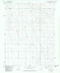
1982 Map of Dunlap Ranch
USGS Topo · Published 1982About this map
Rush Creek meanders across the northern portion of this High Plains landscape, marking a vital water source in an area defined by agricultural development and resource extraction. The boundary between Cheyenne Co and Kiowa Co bisects the northern sections, while the presence of the Dunlap Ranch and several scattered improvements like Well sites point to the region's ranching heritage. Linear patterns of human influence are evident in the Old Railroad Grade cutting through the northwest corner and a pipeline traversing the central corridor. Small-scale industrial activity is grounded in labels for a Drill Hole and the named locality of Quail, reflecting a landscape utilized for more than just surface grazing during the late twentieth century.
Find a feature on this map
7 named features on this map. Tap any name to fly to it.
Don’t see what you’re looking for? This feature index may not catch every label — zoom into the map to look around manually.
Map Details
Editions of this 1982 Dunlap Ranch Map
This is the sole edition of this map. No revisions or reprints were ever made.
Other maps of this area

1891 · Kit Carson
USGS Topo · 1:125,000

1892 · Lamar
USGS Topo · 1:125,000

1893 · Kit Carson
USGS Topo · 1:125,000

1954 · Lamar
USGS Topo · 1:250,000

1958 · Lamar
USGS Topo · 1:250,000
1968 · Alkali Lake
USGS Topo · 1:24,000

1968 · Hawkins
USGS Topo · 1:24,000
1968 · Eads
USGS Topo · 1:24,000

1981 · Cheyenne Wells
USGS Topo · 1:100,000

1982 · Kit Carson 4 NW
USGS Topo · 1:24,000