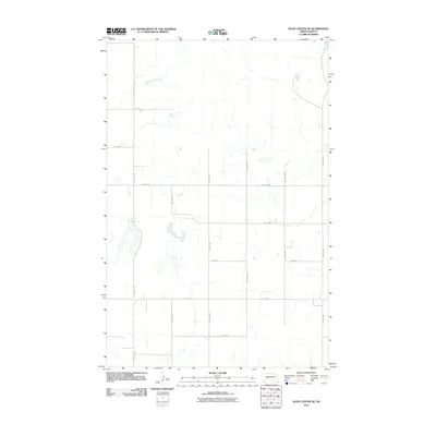
2011 Map of Dunn Center NE
USGS Topo · Published 2011About this map
Chimney Butte Creek meanders across this rural North Dakota landscape, which is defined by a rigorous section-line road grid typical of the Great Plains. The 2011 survey reveals an environment shaped by agricultural organization, where north-south routes like 97th Ave SW and 92nd Ave SW intersect east-west paths such as Main St and 1st St NW. This layout reflects a Century of Land Ordinance surveying, establishing a predictable network for ranching and farming operations. The hydrology is sparse, centered primarily on the creek and its intermittent tributaries, illustrating the arid conditions and drainage patterns of Dunn County at the start of the 21st century.
Find a feature on this map
14 named features on this map. Tap any name to fly to it.
Don’t see what you’re looking for? This feature index may not catch every label — zoom into the map to look around manually.
Map Details
Editions of this 2011 Dunn Center NE Map
This is the sole edition of this map. No revisions or reprints were ever made.
Other maps of this area

1953 · Watford City
USGS Topo · 1:250,000

1957 · Watford City
USGS Topo · 1:250,000

1967 · Watford City
USGS Topo · 1:250,000

1970 · Dunn Center NW
USGS Topo · 1:24,000

1970 · Mandaree SW
USGS Topo · 1:24,000

1970 · Halliday NW
USGS Topo · 1:24,000

1970 · Dunn Center NE
USGS Topo · 1:24,000

1970 · Mandaree SE
USGS Topo · 1:24,000
1970 · Saddle Butte SW
USGS Topo · 1:24,000

1973 · Dunn Center
USGS Topo · 1:24,000