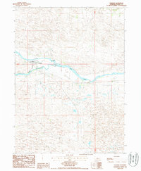
1986 Map of Dunning
USGS Topo · Published 1987About this map
Dunning sits at the confluence where the Dismal River joins the Middle Loup River, serving as a vital focal point in the Nebraska Sandhills during the mid-1980s. The settlement's layout is defined by its relationship to the water and the Burlington Northern railroad, which parallels the river valley. The surrounding terrain is characterized by intricate dune formations and numerous pockets of standing water or wells, illustrating the region's unique hydrology. Beyond the town center, a local Cem and the Radio Tower (Keatin) stand as notable landmarks against the prairie. A Gaging Sta on the riverbank reflects the ongoing importance of water management in this agricultural landscape, while the township and range lines of T22N and T21N provide the underlying grid for land ownership and cattle ranching operations.
Find a feature on this map
10 named features on this map. Tap any name to fly to it.
Don’t see what you’re looking for? This feature index may not catch every label — zoom into the map to look around manually.
Map Details
Editions of this 1986 Dunning Map
This is the sole edition of this map. No revisions or reprints were ever made.
Other maps of this area

1948 · Linscott
USGS Topo · 1:62,500

1950 · Linscott
USGS Topo · 1:62,500

1951 · Dunning
USGS Topo · 1:62,500

1951 · Anselmo NW
USGS Topo · 1:24,000

1952 · Brewster SW
USGS Topo · 1:24,000

1952 · Brewster NW
USGS Topo · 1:24,000

1954 · North Platte
USGS Topo · 1:250,000

1955 · Broken Bow
USGS Topo · 1:250,000

1956 · Broken Bow
USGS Topo · 1:250,000

1956 · North Platte
USGS Topo · 1:250,000