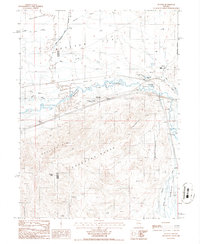
1986 Map of Dunphy
USGS Topo · Published 1986About this map
The Humboldt River carves a winding path through this high desert corridor, separating the broad agricultural expanses of Boulder Flat from the steep rising slopes of the Shoshone Range. This 1980s landscape reveals a classic Great Basin ranching and transportation hub, centered on the small settlement of Dunphy and the nearby Dunphy Ranch. The historical significance of this route is anchored by the Old California Trail, which parallels the river through the northern half of the quadrangle. North of the river, Boulder Valley is characterized by ranching infrastructure like Feedlots and isolated dwellings such as White House and Blue House. To the south, the terrain becomes dramatically more vertical, rising toward Shoshone Point and the Argenta Rim. This region's industrial side is represented by several Prospect sites and a Gravel Pit near Shoshone, highlighting the intersection of transit, resource extraction, and livestock production in Northern Nevada.
Find a feature on this map
30 named features on this map. Tap any name to fly to it.
Don’t see what you’re looking for? This feature index may not catch every label — zoom into the map to look around manually.
Map Details
Editions of this 1986 Dunphy Map
This is the sole edition of this map. No revisions or reprints were ever made.
Other maps of this area

1955 · Winnemucca
USGS Topo · 1:250,000

1957 · Dunphy
USGS Topo · 1:62,500

1957 · Beowawe
USGS Topo · 1:62,500

1958 · Winnemucca
USGS Topo · 1:250,000

1962 · Winnemucca
USGS Topo · 1:250,000

1965 · Sheep Creek Range SW
USGS Topo · 1:24,000

1965 · Sheep Creek Range SE
USGS Topo · 1:24,000

1968 · Rodeo Creek SW
USGS Topo · 1:24,000
1985 · The Geysers
USGS Topo · 1:24,000
1985 · Mule Canyon
USGS Topo · 1:24,000