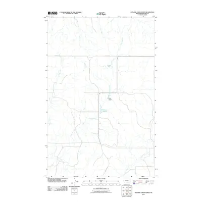
2011 Map of Duplisse Creek North
USGS Topo · Published 2011About this map
Long Grass Creek and its numerous seasonal tributaries carve a complex drainage pattern through this portion of Richland County, as documented in 2011. The landscape is defined by the management of water in an arid environment, notably at the Zinger Number 1 Dam and the nearby Fatzinger Reservoir. Further north, Candee Pond provides another focal point for local hydrology amidst the section lines of the rural grid. This survey highlights the agricultural infrastructure of the region, where County Rd-143 and County Rd 308 provide the primary transit corridors across the drainage basins of Muskrat Creek and Second Creek. The map also captures the headwaters of Duplisse Creek as they trend toward the southeastern corner of the quadrangle, illustrating the subtle topographical variations that dictate the flow of East Redwater Creek.
Find a feature on this map
14 named features on this map. Tap any name to fly to it.
Don’t see what you’re looking for? This feature index may not catch every label — zoom into the map to look around manually.
Map Details
Editions of this 2011 Duplisse Creek North Map
This is the sole edition of this map. No revisions or reprints were ever made.
Other maps of this area

1909 · Glendive
USGS Topo · 1:250,000

1912 · Poplar
USGS Topo · 1:62,500

1914 · Brockton
USGS Topo · 1:62,500

1954 · Glendive
USGS Topo · 1:250,000

1954 · Wolf Point
USGS Topo · 1:250,000

1957 · Glendive
USGS Topo · 1:250,000

1958 · Wolf Point
USGS Topo · 1:250,000

1958 · Glendive
USGS Topo · 1:250,000

1972 · Poplar
USGS Topo · 1:24,000
1972 · Mortarstone Bluff
USGS Topo · 1:24,000