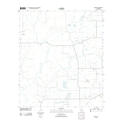
2012 Map of Duralde
USGS Topo · Published 2012About this map
Hampton and Duralde anchor this rural landscape in Allen Parish, where the local economy and geography are defined by a network of oil and gas production. Large extraction zones including the North Basile Oil Field, West Duralde Oil Field, and the East Basile Oil and Gas Field dominate the terrain, interspersed with agricultural fields and the winding paths of Bayou Dülade and Coulee Valentine. The map reveals a deeply rooted local history through family-named roads and landmarks like Cezar Cem and Veillon Cem. This 2012 survey illustrates the transition of the Louisiana prairies into an industrial energy corridor, with transport arteries like L'Anse Aux Vaches Rd and Cottongin Castor Rd providing access to both remote homesteads and energy infrastructure.
Find a feature on this map
46 named features on this map. Tap any name to fly to it.
Don’t see what you’re looking for? This feature index may not catch every label — zoom into the map to look around manually.
Map Details
Editions of this 2012 Duralde Map
This is the sole edition of this map. No revisions or reprints were ever made.
Other maps of this area

1947 · Fruge Lake
USGS Topo · 1:31,680

1947 · Foley
USGS Topo · 1:31,680

1947 · Redland
USGS Topo · 1:31,680

1947 · Elton
USGS Topo · 1:31,680

1947 · Bond
USGS Topo · 1:31,680

1947 · Eunice
USGS Topo · 1:31,680

1947 · Basile
USGS Topo · 1:31,680

1949 · Bayou Blue
USGS Topo · 1:31,680

1949 · Basile
USGS Topo · 1:31,680
1950 · Foley
USGS Topo · 1:31,680