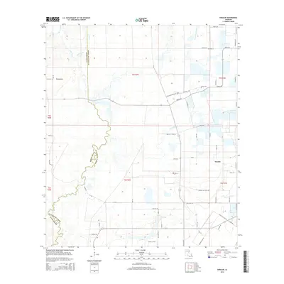
2015 Map of Duralde
USGS Topo · Published 2015About this map
Hampton and Duralde sit within a landscape of low-lying wetlands and meandering waterways along the border of Allen and Evangeline Parishes. The drainage patterns are a central feature of the area, defined by the winding course of Grand Louis Bayou to the north and Coulee Valentine cutting across the center of the sheet. Smaller tributaries like Tiger Point Gully, Castor Creek, and Mulberry Cr highlight the intricate hydrology of this Louisiana coastal plain region.
Find a feature on this map
68 named features on this map. Tap any name to fly to it.
Don’t see what you’re looking for? This feature index may not catch every label — zoom into the map to look around manually.
Map Details
Editions of this 2015 Duralde Map
This is the sole edition of this map. No revisions or reprints were ever made.
Other maps of this area

1947 · Fruge Lake
USGS Topo · 1:31,680

1947 · Foley
USGS Topo · 1:31,680

1947 · Redland
USGS Topo · 1:31,680

1947 · Elton
USGS Topo · 1:31,680

1947 · Bond
USGS Topo · 1:31,680

1947 · Eunice
USGS Topo · 1:31,680

1947 · Basile
USGS Topo · 1:31,680

1949 · Bayou Blue
USGS Topo · 1:31,680

1949 · Basile
USGS Topo · 1:31,680
1950 · Foley
USGS Topo · 1:31,680