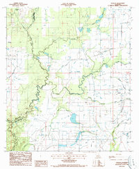
1986 Map of Duralde
USGS Topo · Published 1987About this map
The low-lying prairie and bayou country along the Allen Parish and Evangeline Parish boundary is defined by a dense network of slow-moving waterways and agricultural infrastructure. In the mid-1980s, the landscape around the settlement of Duralde was heavily shaped by water management, featuring numerous flumes, siphons, and wells that supported the local rice and crawfish economy. The wandering path of Bayou Nezpique forms a natural spine through the center of the sheet, where the terrain is marked by distinct coulees and gullies.
Find a feature on this map
16 named features on this map. Tap any name to fly to it.
Don’t see what you’re looking for? This feature index may not catch every label — zoom into the map to look around manually.
Map Details
Editions of this 1986 Duralde Map
This is the sole edition of this map. No revisions or reprints were ever made.
Other maps of this area

1947 · Fruge Lake
USGS Topo · 1:31,680

1947 · Foley
USGS Topo · 1:31,680

1947 · Redland
USGS Topo · 1:31,680

1947 · Elton
USGS Topo · 1:31,680

1947 · Bond
USGS Topo · 1:31,680

1947 · Eunice
USGS Topo · 1:31,680

1947 · Basile
USGS Topo · 1:31,680

1949 · Bayou Blue
USGS Topo · 1:31,680

1949 · Basile
USGS Topo · 1:31,680
1950 · Foley
USGS Topo · 1:31,680