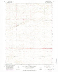
1963 Map of Durham
USGS Topo · Published 1978About this map
Durham sits as the central point of activity in this Laramie County landscape, defined by the steady transit corridors of the Union Pacific railroad and the dual thoroughfares of Highway 80 and Highway 30. The map, reflecting fieldwork from 1963 with revisions through 1978, illustrates a high-plains environment where water sources like Lodgepole Creek and Crow Creek dictated the placement of early infrastructure. The terrain is notably open, marked by a straight-line Pipeline and occasional wells that highlight the region's reliance on underground resources. Settlement patterns here are sparse, with the rail siding and interstate connections serving as the primary anchors for the local geography.
Find a feature on this map
9 named features on this map. Tap any name to fly to it.
Don’t see what you’re looking for? This feature index may not catch every label — zoom into the map to look around manually.
Map Details
Editions of this 1963 Durham Map
2 editions found
Other maps of this area

1911 · Cheyenne
USGS Topo · 1:125,000

1914 · Cheyenne
USGS Topo · 1:125,000

1954 · Cheyenne
USGS Topo · 1:250,000

1958 · Cheyenne
USGS Topo · 1:250,000

1963 · Arcola
USGS Topo · 1:24,000

1963 · Pole Creek Ranch SE
USGS Topo · 1:24,000

1963 · Durham
USGS Topo · 1:24,000

1963 · Midway SW
USGS Topo · 1:24,000
1963 · Pole Creek Ranch
USGS Topo · 1:24,000
1963 · Hillsdale
USGS Topo · 1:24,000