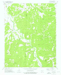
1973 Map of Durham
USGS Topo · Published 1976About this map
The White River carves a winding path through the Ozark highlands of Washington and Madison counties, anchoring the small settlements of Durham, Thompson, and Crosses during the early 1970s. The landscape is defined by its deep hollows and named peaks, including Chicken Bristle Mountain and Bushart Mountain, which provided the topographic isolation for numerous small community landmarks. Genealogists will find a cluster of burial grounds and rural houses of worship, such as Mt Olive Cem, Walnut Grove Cem, and Shumate Ch, scattered along the river's tributaries. The presence of a Pipeline and a Radio Tower on Hobbs Mountain indicate mid-century utility expansion into this terrain, while older names like Chicken Bristle Creek and Shaffer Bluff speak to the area's earlier settler history.
Find a feature on this map
49 named features on this map. Tap any name to fly to it.
Don’t see what you’re looking for? This feature index may not catch every label — zoom into the map to look around manually.
Map Details
Editions of this 1973 Durham Map
This is the sole edition of this map. No revisions or reprints were ever made.
Other maps of this area

1898 · Winslow
USGS Topo · 1:125,000

1899 · Fayetteville
USGS Topo · 1:125,000

1900 · Eureka Springs
USGS Topo · 1:125,000

1901 · Winslow
USGS Topo · 1:125,000

1901 · Eureka Springs
USGS Topo · 1:125,000

1901 · Fayetteville
USGS Topo · 1:125,000

1904 · Fayetteville
USGS Topo · 1:125,000

1943 · St. Paul
USGS Topo · 1:62,500

1945 · Harrison
USGS Topo · 1:250,000

1946 · St. Paul
USGS Topo · 1:62,500