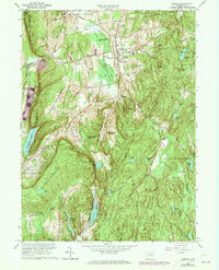
1964 Map of Durham
USGS Topo · Published 1973About this map
Durham and Durham Center serve as the primary hubs in this central Connecticut landscape, where the valley floor transitions into the prominent ridges of Beseck Mountain and Pistapaug Mountain. The area is defined by its extensive water network and conservation lands, including the Durham Meadows Hunting Area and the sprawling Cockaponset State Forest. Significant infrastructure of the mid-20th century is visible, such as the Penn Central railroad line cutting through the northwest and the Menunkatuck Reservoir in the south. Local landmarks like the Korn Sch and the Allyn Millpond offer specific points of interest for those tracing community history. The ridge-top Guilford Lookout Tower and trails like the Trimountain Trail and Mattabesett Trail highlight a long-standing commitment to recreation and forest management across the Middlesex and New Haven county lines.
Find a feature on this map
70 named features on this map. Tap any name to fly to it.
Don’t see what you’re looking for? This feature index may not catch every label — zoom into the map to look around manually.
Map Details
Editions of this 1964 Durham Map
4 editions found
Other maps of this area

1892 · New Haven
USGS Topo · 1:62,500

1892 · Meriden
USGS Topo · 1:62,500

1893 · Guilford
USGS Topo · 1:62,500

1893 · Middletown
USGS Topo · 1:62,500

1893 · Meriden
USGS Topo · 1:62,500

1906 · Farmington
USGS Topo · 1:125,000

1921 · New Haven
USGS Topo · 1:62,500

1928 · Cromwell
USGS Topo · 1:24,000

1943 · Durham
USGS Topo · 1:25,000

1945 · Middle Haddam
USGS Topo · 1:31,680