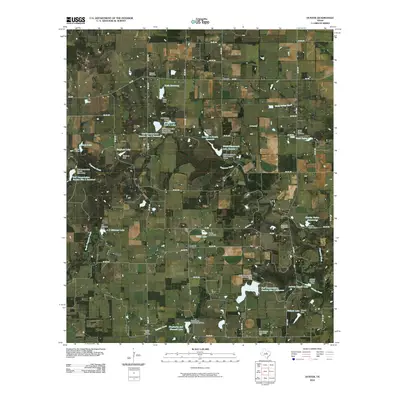
2010 Map of Duster
USGS Topo · Published 2010About this map
Ninevah Cemetery and the crossroads at Duster anchor this rural landscape in Comanche County. The terrain is defined by a network of seasonal watercourses including Copperas Creek, North Turkey Creek, and Martins Creek, which have been extensively managed through local water conservation efforts. Dozens of small-scale dams and reservoirs, such as Keith Reservoir and the Wolfe Pecanlands Lake Number 1, illustrate the intensive agricultural land use and water management priorities of the early 21st century. Further south, the community of Beattie sits near Welch Lake, while scattered landmarks like the Soda Springs Community Hall serve as focal points for the dispersed population. Genealogists will find several burial grounds across the quadrangle, including the Turkey Creek Cemetery and Martins Creek Cemetery, marking the locations of established family settlements.
Find a feature on this map
70 named features on this map. Tap any name to fly to it.
Don’t see what you’re looking for? This feature index may not catch every label — zoom into the map to look around manually.
Map Details
Editions of this 2010 Duster Map
This is the sole edition of this map. No revisions or reprints were ever made.
Other maps of this area

1889 · Brownwood
USGS Topo · 1:125,000

1894 · Eastland
USGS Topo · 1:125,000

1894 · Brownwood
USGS Topo · 1:125,000

1954 · Brownwood
USGS Topo · 1:250,000

1954 · Abilene
USGS Topo · 1:250,000

1958 · Abilene
USGS Topo · 1:250,000

1966 · Star Mountain
USGS Topo · 1:24,000

1966 · Sipe Springs
USGS Topo · 1:24,000
1968 · Rucker
USGS Topo · 1:24,000
1968 · Gorman
USGS Topo · 1:24,000