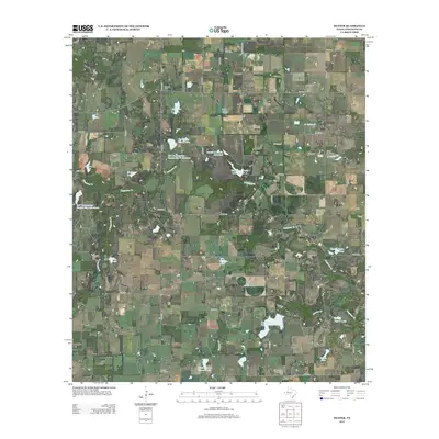
2012 Map of Duster
USGS Topo · Published 2012About this map
The unincorporated community of Duster and the settlement of Beattie anchor this rural landscape in Comanche County, where a complex network of county roads connects family farms and ranches. The terrain is defined by the drainage of Copperas Cr and Martins Cr, punctuated by numerous reservoirs such as Keith Reservoir and the uniquely named Wolfe Pecanlands Lake Number 1. This 2012 survey illustrates a modern rural Texas environment where historical centers of community life remain visible through sites like the Soda Springs Community Hall. Genealogists will find significant value in the distribution of local burial grounds, including Ninevah Cem, Turkey Creek Cem, and Copperas Cem, which are scattered throughout the region. The map also shows significant land management through several Soil Conservation Service reservoirs, reflecting the agricultural priorities and water management strategies of this central Texas area.
Find a feature on this map
62 named features on this map. Tap any name to fly to it.
Don’t see what you’re looking for? This feature index may not catch every label — zoom into the map to look around manually.
Map Details
Editions of this 2012 Duster Map
This is the sole edition of this map. No revisions or reprints were ever made.
Other maps of this area

1889 · Brownwood
USGS Topo · 1:125,000

1894 · Eastland
USGS Topo · 1:125,000

1894 · Brownwood
USGS Topo · 1:125,000

1954 · Brownwood
USGS Topo · 1:250,000

1954 · Abilene
USGS Topo · 1:250,000

1958 · Abilene
USGS Topo · 1:250,000

1966 · Star Mountain
USGS Topo · 1:24,000

1966 · Sipe Springs
USGS Topo · 1:24,000
1968 · Rucker
USGS Topo · 1:24,000
1968 · Gorman
USGS Topo · 1:24,000