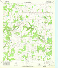
1969 Map of Duster
USGS Topo · Published 1972About this map
The rural landscape of Comanche County is defined by a dense network of seasonal waterways and local burial grounds, centered on the community of Duster. In the late 1960s, this area maintained a traditional settlement pattern, where small clusters of life revolved around local institutions like the Soda Springs Community Hall and several scattered churches including Taylors Chapel and the Church of Christ in Beattie. The map reveals a transition toward energy extraction, with numerous labels for Gas Well sites interspersed among old family-named landmarks.
Find a feature on this map
19 named features on this map. Tap any name to fly to it.
Don’t see what you’re looking for? This feature index may not catch every label — zoom into the map to look around manually.
Map Details
Editions of this 1969 Duster Map
This is the sole edition of this map. No revisions or reprints were ever made.
Other maps of this area

1889 · Brownwood
USGS Topo · 1:125,000

1894 · Eastland
USGS Topo · 1:125,000

1894 · Brownwood
USGS Topo · 1:125,000

1954 · Brownwood
USGS Topo · 1:250,000

1954 · Abilene
USGS Topo · 1:250,000

1958 · Abilene
USGS Topo · 1:250,000

1966 · Star Mountain
USGS Topo · 1:24,000

1966 · Sipe Springs
USGS Topo · 1:24,000
1968 · Rucker
USGS Topo · 1:24,000
1968 · Gorman
USGS Topo · 1:24,000