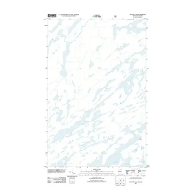
2011 Map of Dutton Lake
USGS Topo · Published 2011About this map
Ottertrack Lake and South Arm Knife Lake dominate this remote northern landscape along the boundary between Minnesota and Ontario. This 2011 survey reveals a territory defined entirely by its complex hydrography, where narrow fingers of water and irregular shorelines suggest a glacier-carved terrain. The map serves as a vital guide for those navigating the historical water routes of the borderlands, specifically identifying the Little Knife Portage as a critical overland link between major water bodies. Smaller, isolated basins such as Dutton Lake, Conic Lake, Topaz Lake, and Amoeber Lake are scattered throughout the quadrangle, illustrating the dense network of interior lakes that characterize this wilderness region. There are no roads or permanent settlements recorded on this sheet, emphasizing the area's preservation as a primitive aquatic corridor.
Find a feature on this map
7 named features on this map. Tap any name to fly to it.
Don’t see what you’re looking for? This feature index may not catch every label — zoom into the map to look around manually.
Map Details
Editions of this 2011 Dutton Lake Map
This is the sole edition of this map. No revisions or reprints were ever made.
Other maps of this area

1957 · Ensign Lake
USGS Topo · 1:62,500

1957 · Quetico
USGS Topo · 1:250,000

1959 · Ogishkemuncie Lake
USGS Topo · 1:24,000

1959 · Kekekabic Lake
USGS Topo · 1:24,000

1959 · Dutton Lake
USGS Topo · 1:24,000

1959 · Ester Lake
USGS Topo · 1:24,000

1968 · Quetico
USGS Topo · 1:250,000
1976 · Ensign Lake SE
USGS Topo · 1:24,000

1977 · Basswood Lake
USGS Topo · 1:100,000
1981 · Ensign Lake East
USGS Topo · 1:24,000