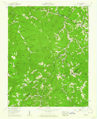
1958 Map of Duty
USGS Topo · Published 1960About this map
Moss No 3 Mine and nearby strip mines mark the industrial character of this corner of the Appalachian Plateau during the late 1950s. The landscape is defined by the sharp convergence of Long Ridge, Sandy Ridge, and Divide Ridge, where the borders of Dickenson, Buchanan, and Russell Counties meet. This rugged topography dictated a settlement pattern of isolated farmsteads and small communities like Davenport and Duty tucked into narrow hollows and gaps.
Find a feature on this map
75 named features on this map. Tap any name to fly to it.
Don’t see what you’re looking for? This feature index may not catch every label — zoom into the map to look around manually.
Map Details
Editions of this 1958 Duty Map
Other maps of this area

1886 · Grundy
USGS Topo · 1:125,000

1890 · Grundy
USGS Topo · 1:125,000

1892 · Grundy
USGS Topo · 1:125,000

1897 · Bristol
USGS Topo · 1:125,000

1902 · Bristol
USGS Topo · 1:125,000

1913 · Clintwood
USGS Topo · 1:62,500

1914 · Bucu
USGS Topo · 1:48,000

1915 · Clintwood
USGS Topo · 1:62,500

1916 · Bucu
USGS Topo · 1:62,500

1918 · Carterton
USGS Topo · 1:62,500