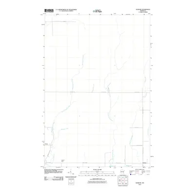
2010 Map of Duxbury
USGS Topo · Published 2010About this map
The settlement of Duxbury anchors the southeastern corner of this Pine County landscape, where the Lower Tamarack River and Tamarack River converge. This area is defined by a dense network of waterways, including the winding West Fork Crooked Creek and East Fork Crooked Creek, which feed into Crooked Lake and Dollar Lake. Local history is anchored by Danforth Cemetery, located near the western edge along Fleming Jogging Rd. The terrain features several family-named and descriptive roads like Starch Rd, Rutabaga Rd, and Vink Rd. Elevated views of the surrounding wetlands and forests were once provided by the Eaglehead Lookout Tower, a prominent landmark situated near County Hwy-30 and Wolf Creek.
Find a feature on this map
21 named features on this map. Tap any name to fly to it.
Don’t see what you’re looking for? This feature index may not catch every label — zoom into the map to look around manually.
Map Details
Editions of this 2010 Duxbury Map
This is the sole edition of this map. No revisions or reprints were ever made.
Other maps of this area

1949 · Danbury
USGS Topo · 1:48,000

1949 · Holyoke
USGS Topo · 1:48,000

1953 · Duluth
USGS Topo · 1:250,000

1958 · Duluth
USGS Topo · 1:250,000

1962 · Holyoke
USGS Topo · 1:62,500

1962 · Bruno
USGS Topo · 1:62,500

1962 · Cloverdale
USGS Topo · 1:62,500

1962 · Danbury
USGS Topo · 1:62,500

1980 · Sandstone
USGS Topo · 1:100,000
1981 · Cloverdale
USGS Topo · 1:24,000