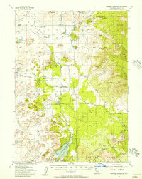
1954 Map of Dwinnell Reservoir
USGS Topo · Published 1957About this map
Shasta Valley dominates this 1950s landscape, characterized by its complex network of irrigation ditches, springs, and the expansive Dwinnell Reservoir. The map reveals a transition between the volcanic terrain of the Shasta National Forest and the agricultural flats surrounding the Little Shasta River. Local life centers around rural institutions like the Hovey Gulch School and Big Springs School, while the Little Shasta Cem provides a point of interest for genealogists tracing early families of Little Shasta. The era's infrastructure is clearly visible, from the Southern Pacific rail line in the south to the Copco Substation and an Airway Beacon for early aviation. Geologic features like Pluto Cave and Table Rock stand out against the patterned lava flows that define the eastern portion of the quadrangle.
Find a feature on this map
42 named features on this map. Tap any name to fly to it.
Don’t see what you’re looking for? This feature index may not catch every label — zoom into the map to look around manually.
Map Details
Editions of this 1954 Dwinnell Reservoir Map
4 editions found
Other maps of this area

1886 · Shasta
USGS Topo · 1:250,000

1894 · Shasta
USGS Topo · 1:250,000

1921 · Shasta Valley Sheet No 7
USGS Topo · 1:24,000

1921 · Shasta Valley Sheet No 11
USGS Topo · 1:24,000

1921 · Shasta Valley Sheet No 1
USGS Topo · 1:24,000

1921 · Shasta Valley Sheet No 6
USGS Topo · 1:24,000

1921 · Shasta Valley Sheet No 2
USGS Topo · 1:24,000

1922 · Shasta Valley Sheet No 10
USGS Topo · 1:24,000

1922 · Shasta Valley Sheet No 10 E
USGS Topo · 1:24,000

1922 · Shasta Valley Sheet No 12
USGS Topo · 1:24,000