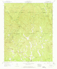
1959 Map of Dyer Gap
USGS Topo · Published 1975About this map
Cohutta Mountain and the Parkis Ridge dominate this rugged terrain at the intersection of Fannin, Gilmer, and Murray counties. The landscape is defined by the high elevations of the Chattahoochee National Forest and the Cohutta Wildlife Management Area, where numerous gaps like Dyer Gap and Sassafras Gap provided essential passage through the Blue Ridge Mountain range. While primarily mountainous, the southern portion of the map reveals the social fabric of the era through scattered landmarks such as the Henry Grady Sch and Nine Mile Ch. These features, along with Zion Hill Ch and several small cemeteries, indicate a dispersed rural community reliant on a network of wagon and jeep tracks. The drainage patterns of the Conasauga River and Mountaintown Creek shaped the early settlement locations, including the remote Law Grounds.
Find a feature on this map
61 named features on this map. Tap any name to fly to it.
Don’t see what you’re looking for? This feature index may not catch every label — zoom into the map to look around manually.
Map Details
Editions of this 1959 Dyer Gap Map
3 editions found
Other maps of this area

1886 · Dalton
USGS Topo · 1:125,000

1888 · Ellijay
USGS Topo · 1:125,000

1892 · Ellijay
USGS Topo · 1:125,000

1892 · Dalton
USGS Topo · 1:125,000

1897 · Dalton
USGS Topo · 1:125,000

1898 · Ellijay
USGS Topo · 1:125,000

1911 · Ellijay
USGS Topo · 1:125,000

1911 · Cohutta Mtn
USGS Topo · 1:62,500

1913 · Cohutta Mtn.
USGS Topo · 1:62,500

1914 · Talking Rock
USGS Topo · 1:62,500