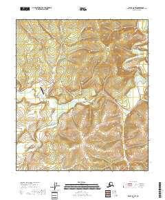
2018 Map of Eagle A-2 SW
USGS Topo · Published 2018About this map
Chicken serves as the focal point of this interior Alaska landscape, situated where the Taylor Highway meets Chicken Airport Road. The settlement's proximity to the South Fork Fortymile River and its major tributaries, including the Mosquito Fork and Dennison Fork, highlights a landscape defined by historic gold-bearing waters. The topography is anchored by the prominent Lost Chicken Hill and dissected by numerous creeks such as Chicken Cr and Myers Fork. This 2018 survey reveals the infrastructure supporting this remote community, from the Chicken Airport to the winding course of the highway, reflecting the persistent importance of river access and small-scale aviation in the Fortymile district. The convergence of multiple forks of the Fortymile River system illustrates a drainage pattern that has historically guided prospecting and transportation through the region.
Find a feature on this map
25 named features on this map. Tap any name to fly to it.
Don’t see what you’re looking for? This feature index may not catch every label — zoom into the map to look around manually.
Map Details
Editions of this 2018 Eagle A-2 SW Map
This is the sole edition of this map. No revisions or reprints were ever made.
Other maps of this area

1899 · Fortymile
USGS Topo · 1:250,000

1949 · Tanacross
USGS Topo · 1:250,000

1950 · Tanacross
USGS Topo · 1:250,000

1951 · Eagle
USGS Topo · 1:250,000

1956 · Tanacross D-3
USGS Topo · 1:63,360

1956 · Tanacross D-2
USGS Topo · 1:63,360

1956 · Eagle A-2
USGS Topo · 1:63,360

1956 · Tanacross
USGS Topo · 1:250,000
1957 · Eagle A-3
USGS Topo · 1:63,360

1957 · Eagle
USGS Topo · 1:250,000