
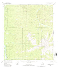
1956 Map of Tanacross D-2
USGS Topo · Published 1962About this map
The Dennison Fork winds through the western edge of this territory, defining a landscape carved by a network of drainage basins. In the mid-1950s, this region of the eastern interior remained largely unsettled, characterized by topographical survey points like VABM Atwater 3697 and VABM Paine 4875 that served as the primary landmarks for mapping the wilderness. The drainage patterns of Gold Bar Creek and Big Timber Creek indicate a complex watershed where water bodies and terrain elevations were the defining features of the district. The absence of roads or established towns highlights the area's isolation during this era, with only trails providing a minimal human imprint on the land. Smaller tributaries such as Cement Creek and Palisade Creek feed into the larger systems, illustrating the hydraulic connectivity that dominated local geography before modern development reached this part of the Alaska interior.
Find a feature on this map
10 named features on this map. Tap any name to fly to it.
Don’t see what you’re looking for? This feature index may not catch every label — zoom into the map to look around manually.
Map Details
Editions of this 1956 Tanacross D-2 Map
2 editions found
Other maps of this area

1899 · Fortymile
USGS Topo · 1:250,000

1949 · Tanacross
USGS Topo · 1:250,000

1950 · Tanacross
USGS Topo · 1:250,000

1951 · Eagle
USGS Topo · 1:250,000

1956 · Tanacross D-3
USGS Topo · 1:63,360

1956 · Tanacross C-1
USGS Topo · 1:63,360

1956 · Tanacross C-3
USGS Topo · 1:63,360

1956 · Tanacross C-2
USGS Topo · 1:63,360

1956 · Tanacross D-1
USGS Topo · 1:63,360

1956 · Eagle A-1
USGS Topo · 1:63,360