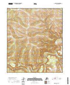
2018 Map of Eagle B-1 SE
USGS Topo · Published 2018About this map
The Fortymile River winds through this remote interior landscape, a region deeply tied to the history of northern prospecting. The presence of Bonanza Bar and Nugget Gulch points to the area's legacy of placer mining, where gold seekers worked the gravels of the river and its many tributaries. The terrain is defined by a dense network of drainages including Sam Patch Cr, Dick Dale Cr, and Discovery Cr, each carving through the high country. Near the southern river bend, Deadman Island sits as a prominent landmark within the active channel. This 2018 survey by the U.S. Geological Survey provides a precise record of the physical geography and hydrography within the Southeast Fairbanks Census Area, documenting the persistent named features of this sparsely settled wilderness.
Find a feature on this map
18 named features on this map. Tap any name to fly to it.
Don’t see what you’re looking for? This feature index may not catch every label — zoom into the map to look around manually.
Map Details
Editions of this 2018 Eagle B-1 SE Map
This is the sole edition of this map. No revisions or reprints were ever made.
Other maps of this area

1899 · Fortymile
USGS Topo · 1:250,000

1951 · Eagle
USGS Topo · 1:250,000

1956 · Eagle A-1
USGS Topo · 1:63,360

1956 · Eagle B-1
USGS Topo · 1:63,360

1957 · Eagle
USGS Topo · 1:250,000
2018 · Eagle A-1 NW
USGS Topo · 1:25,000
2018 · Eagle B-1 NW
USGS Topo · 1:25,000
2018 · Eagle B-1 NE
USGS Topo · 1:25,000
2018 · Eagle B-1 SW
USGS Topo · 1:25,000
2018 · Eagle A-1 NE
USGS Topo · 1:25,000