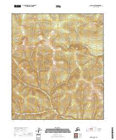
2018 Map of Eagle B-2 NE
USGS Topo · Published 2018About this map
Alder Cr and Columbia Cr define the drainage patterns of this high-latitude terrain within the Southeast Fairbanks Census Area. This part of the Alaska interior is characterized by its high-elevation contour work, documenting the headwaters and drainages before they join larger river systems. The map detail highlights the specific legal land partitions, including t5s r30e, t5s r31e, t6s r30e, and t6s r31e, which are essential for identifying historical mining claims or land allotments. While largely unsettled, the presence of King Cr in the lower reaches provides a specific geographic marker for those studying the hydrology of the Eagle region in the early twenty-first century.
Find a feature on this map
7 named features on this map. Tap any name to fly to it.
Don’t see what you’re looking for? This feature index may not catch every label — zoom into the map to look around manually.
Map Details
Editions of this 2018 Eagle B-2 NE Map
This is the sole edition of this map. No revisions or reprints were ever made.
Other maps of this area

1899 · Fortymile
USGS Topo · 1:250,000

1951 · Eagle
USGS Topo · 1:250,000

1956 · Eagle C-1
USGS Topo · 1:63,360

1956 · Eagle C-2
USGS Topo · 1:63,360

1956 · Eagle B-2
USGS Topo · 1:63,360

1956 · Eagle B-1
USGS Topo · 1:63,360

1957 · Eagle
USGS Topo · 1:250,000
2018 · Eagle B-2 NW
USGS Topo · 1:25,000
2018 · Eagle B-2 SE
USGS Topo · 1:25,000
2018 · Eagle C-2 SE
USGS Topo · 1:25,000