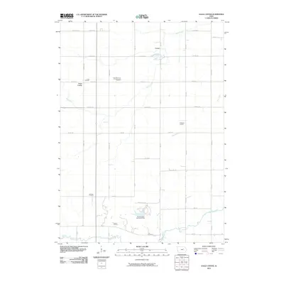
2010 Map of Eagle Center
USGS Topo · Published 2010About this map
Saint Mary's of Mount Carmel Cemetery and Eagle Cemetery anchor the rural landscape of Black Hawk County, reflecting the deep-seated communal and religious foundations of this Iowa farming region. The settlement of Eagle Center serves as a local hub, while the small community of Louise is situated to the northeast near the upper reaches of Miller Creek. The map reveals a highly structured grid of section roads, including W Eagle Rd and Kimball Ave, which delineate the productive agricultural tracts that define the area's economy. In the southern portion of the quadrangle, the terrain transitions toward the winding course of Wolf Creek, where the Hickory Hills Recreation Dam provides a localized water feature and park space. Genealogists will find the distribution of burial sites particularly useful, with Geneseo Cemetery, Spencer Cemetery, and Hill Cemetery scattered across the township, marking the legacy of early families in the district.
Find a feature on this map
39 named features on this map. Tap any name to fly to it.
Don’t see what you’re looking for? This feature index may not catch every label — zoom into the map to look around manually.
Map Details
Editions of this 2010 Eagle Center Map
This is the sole edition of this map. No revisions or reprints were ever made.
Other maps of this area

1954 · Waterloo
USGS Topo · 1:250,000

1955 · Waterloo
USGS Topo · 1:250,000

1963 · Buckingham
USGS Topo · 1:24,000

1963 · Hudson
USGS Topo · 1:24,000

1963 · Waterloo South
USGS Topo · 1:24,000

1963 · Eagle Center
USGS Topo · 1:24,000

1971 · Gilbertville
USGS Topo · 1:24,000
1971 · Dysart
USGS Topo · 1:24,000

1971 · La Porte City
USGS Topo · 1:24,000

1971 · Traer
USGS Topo · 1:24,000