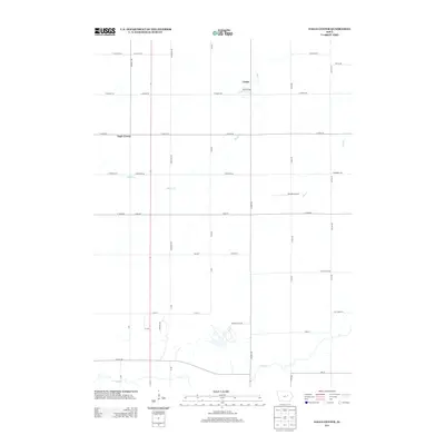
2013 Map of Eagle Center
USGS Topo · Published 2013About this map
The small settlement of Eagle Center and the nearby community of Louise define this rural landscape in Black Hawk County. Located just south of Waterloo, the area is characterized by an extensive grid of agricultural roads, including family-named routes like Bienfang Dr and Eastman Rd. The terrain is drained by several meandering waterways, most notably Miller Cr, Mud Cr, and Wolf Cr, which provide natural relief to the structured section lines. A distinct aviation presence is noted at Nichols Airport, situated near the center of the quadrangle. This 2013 survey illustrates the enduring agricultural layout of the region, where local landmarks are often tied to the road network, such as 115th St and Dysart Rd, marking the transition between township sections and rural homesteads.
Find a feature on this map
42 named features on this map. Tap any name to fly to it.
Don’t see what you’re looking for? This feature index may not catch every label — zoom into the map to look around manually.
Map Details
Editions of this 2013 Eagle Center Map
This is the sole edition of this map. No revisions or reprints were ever made.
Other maps of this area

1954 · Waterloo
USGS Topo · 1:250,000

1955 · Waterloo
USGS Topo · 1:250,000

1963 · Buckingham
USGS Topo · 1:24,000

1963 · Hudson
USGS Topo · 1:24,000

1963 · Waterloo South
USGS Topo · 1:24,000

1963 · Eagle Center
USGS Topo · 1:24,000

1971 · Gilbertville
USGS Topo · 1:24,000
1971 · Dysart
USGS Topo · 1:24,000

1971 · La Porte City
USGS Topo · 1:24,000

1971 · Traer
USGS Topo · 1:24,000