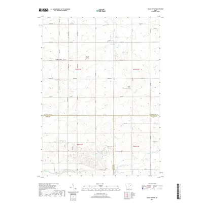
2018 Map of Eagle Center
USGS Topo · Published 2018About this map
Eagle Center serves as the primary community anchor in this rural portion of Iowa where the borders of Black Hawk, Tama, and Benton Counties converge. The landscape is defined by a dense grid of section roads and several winding watercourses, including Miller Cr and Wolf Creek. For those tracing local families, the map preserves the locations of several burial grounds such as Saint Mary's of Mount Carmel Cem, Geneseo Cem, and Spencer Cem. The presence of Nichols Airport near the center of the sheet reflects the agricultural aviation needs of the region. This 2018 survey detail provides a clear look at the intersection of local infrastructure and the natural drainage patterns that have shaped farming life in these three counties for generations.
Find a feature on this map
53 named features on this map. Tap any name to fly to it.
Don’t see what you’re looking for? This feature index may not catch every label — zoom into the map to look around manually.
Map Details
Editions of this 2018 Eagle Center Map
This is the sole edition of this map. No revisions or reprints were ever made.
Other maps of this area

1954 · Waterloo
USGS Topo · 1:250,000

1955 · Waterloo
USGS Topo · 1:250,000

1963 · Buckingham
USGS Topo · 1:24,000

1963 · Hudson
USGS Topo · 1:24,000

1963 · Waterloo South
USGS Topo · 1:24,000

1963 · Eagle Center
USGS Topo · 1:24,000

1971 · Gilbertville
USGS Topo · 1:24,000
1971 · Dysart
USGS Topo · 1:24,000

1971 · La Porte City
USGS Topo · 1:24,000

1971 · Traer
USGS Topo · 1:24,000