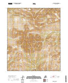
2018 Map of Eagle D-3 SE
USGS Topo · Published 2018About this map
Mertie Mountains dominate the northwestern corner of this remote Alaskan interior landscape, rising above a complex network of high-elevation drainages. This 2018 survey reveals the high-altitude topography of the Southeast Fairbanks Census Area, where the terrain reaches its apex at North Peak in the central part of the quadrangle. Below these heights, the headwaters of Mogul Cr flow eastward, cutting through steep contours that reflect the high-relief nature of the region. The map provides a precise look at the township and range divisions across this undeveloped wilderness, including T1N R27E and T1S R28E, capturing a landscape defined by significant elevation changes and glacial-carved drainages before they descend toward more established river valleys.
Find a feature on this map
11 named features on this map. Tap any name to fly to it.
Don’t see what you’re looking for? This feature index may not catch every label — zoom into the map to look around manually.
Map Details
Editions of this 2018 Eagle D-3 SE Map
This is the sole edition of this map. No revisions or reprints were ever made.
Other maps of this area

1899 · Fortymile
USGS Topo · 1:250,000

1951 · Eagle
USGS Topo · 1:250,000

1956 · Eagle D-2
USGS Topo · 1:63,360

1956 · Eagle C-2
USGS Topo · 1:63,360

1956 · Eagle D-3
USGS Topo · 1:63,360

1956 · Eagle C-3
USGS Topo · 1:63,360

1957 · Eagle
USGS Topo · 1:250,000
2018 · Eagle D-3 SW
USGS Topo · 1:25,000
2018 · Eagle C-3 NE
USGS Topo · 1:25,000
2018 · Eagle D-2 SW
USGS Topo · 1:25,000