
1956 Map of Eagle C-3
USGS Topo · Published 1964About this map
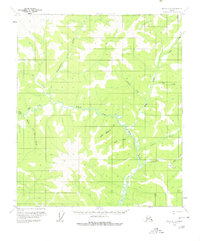
The North Fork Fortymile River serves as the central drainage for this section of the Yukon-Koyukuk region, winding through a landscape defined by its network of seasonal and perennial waterways. This 1956 field-annotated survey captures the area before modern development, showing unsurveyed land lines as predetermined by the Bureau of Land Management. The naming conventions found along the tributaries suggest a history of exploration or prospecting, with sequential labels such as Merry Christmas Creek, Happy Creek, and New Year Creek flowing into the river from the west. Other drainage systems like Independence Creek and Champion Creek further illustrate the topographical complexity of this wilderness area during the mid-1950s, a period when much of the terrain was mapped primarily via aerial photography.
Find a feature on this map
10 named features on this map. Tap any name to fly to it.
Don’t see what you’re looking for? This feature index may not catch every label — zoom into the map to look around manually.
Map Details
Editions of this 1956 Eagle C-3 Map
2 editions found
Other maps of this area

1899 · Fortymile
USGS Topo · 1:250,000

1951 · Eagle
USGS Topo · 1:250,000

1956 · Eagle D-2
USGS Topo · 1:63,360

1956 · Eagle C-2
USGS Topo · 1:63,360

1956 · Eagle B-2
USGS Topo · 1:63,360

1956 · Eagle D-3
USGS Topo · 1:63,360

1956 · Eagle B-3
USGS Topo · 1:63,360

1956 · Eagle B-4
USGS Topo · 1:63,360
1956 · Eagle D-4
USGS Topo · 1:63,360
1956 · Eagle C-4
USGS Topo · 1:63,360