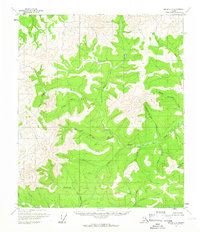
1956 Map of Eagle C-4
USGS Topo · Published 1966About this map
Gold Run Landing Strip serves as a central landmark in this remote Alaskan wilderness, surveyed in the mid-1950s. The landscape is defined by an intricate network of drainages, many bearing distinctive names like Merry Christmas Creek, Happy New Year Creek, and Fourth of July Creek. These seasonal and perennial waters highlight the region's connection to early prospectors and explorers who named the terrain based on the calendar or their hopes for fortune.
Find a feature on this map
21 named features on this map. Tap any name to fly to it.
Don’t see what you’re looking for? This feature index may not catch every label — zoom into the map to look around manually.
Map Details
Editions of this 1956 Eagle C-4 Map
2 editions found
Other maps of this area

1951 · Eagle
USGS Topo · 1:250,000

1956 · Eagle D-3
USGS Topo · 1:63,360

1956 · Eagle B-3
USGS Topo · 1:63,360

1956 · Eagle B-5
USGS Topo · 1:63,360

1956 · Eagle B-4
USGS Topo · 1:63,360

1956 · Eagle C-3
USGS Topo · 1:63,360
1956 · Eagle D-5
USGS Topo · 1:63,360
1956 · Eagle D-4
USGS Topo · 1:63,360

1956 · Eagle C-5
USGS Topo · 1:63,360

1957 · Eagle
USGS Topo · 1:250,000