
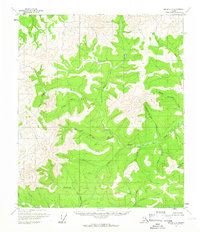
1956 Map of Eagle B-5
USGS Topo · Published 1964About this map
Joseph sits as a primary point of human activity in this isolated interior Alaskan landscape, marked by a remote Airstrip that highlights the era's reliance on bush aviation for access to the backcountry. The terrain is dominated by the winding course of the North Fork Fortymile River, which joins the main Fortymile River at a sharp bend in the topography. This river system, legendary for its place in early prospecting, is fed by several named tributaries including Joseph Creek and Enterprise Creek. The 1956 field annotations capture the area at a time when traditional land use and mineral exploration relied on these watercourses and isolated landing strips rather than a developed road network. The presence of Gold Bottom Creek in the southeastern corner points to the region's enduring connection to the placer mining history of the Yukon-Tanana Uplands.
Find a feature on this map
8 named features on this map. Tap any name to fly to it.
Don’t see what you’re looking for? This feature index may not catch every label — zoom into the map to look around manually.
Map Details
Editions of this 1956 Eagle B-5 Map
This is the sole edition of this map. No revisions or reprints were ever made.
Other maps of this area

1951 · Eagle
USGS Topo · 1:250,000

1956 · Eagle A-5
USGS Topo · 1:63,360

1956 · Eagle B-4
USGS Topo · 1:63,360

1956 · Eagle A-4
USGS Topo · 1:63,360

1956 · Eagle C-6
USGS Topo · 1:63,360

1956 · Eagle A-6
USGS Topo · 1:63,360

1956 · Eagle B-6
USGS Topo · 1:63,360

1956 · Eagle C-5
USGS Topo · 1:63,360
1956 · Eagle C-4
USGS Topo · 1:63,360

1957 · Eagle
USGS Topo · 1:250,000